Pages

Monday, 23 March 2015

Rakiura Track: An NZ Great Walk

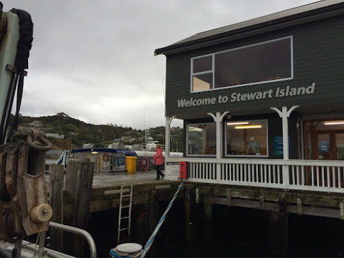
There are nine Great Walk's in New Zealand and are all run and operated by the Department of Conservation (DOC). They tend to be more expensive but the trails are very well maintained, the huts are exeptional and the number of hikers are limited. We decided to do the Rakiura Track because of its location. This track is on Stewart Island which is a one hour ferry ride south from the NZ south island (to NZ's "third" island). It sees less traffic which is what attracted us and there is a higher chance of seeing Kiwi birds in the wild (the sub-species here are active during the day and night here whereas on the north and south islands they are only active at night).

The track starts 5 km north of the town of Oban and takes three days/two nights for a total of 32 km. The route runs along some beaches (at low tide).

and through the Podocarp forest (what is a Podocarp forest? click here).

We did not see any Kiwi's but I did hear their calls our first night which sounds like "Kee-wee". We did see a lot of other birds though: Bellbirds, Tuis (I think their calls sound like R2-D2 from Starwars - click here for a video), Fantails, Kaka (parrot), Seagulls and Wood pigeons. We did see a few Albatross hanging out at the ferry terminal too. They are the worlds biggest sea birds with a wingspan up to 3.3m long!

Kaka
Albatross

The night sky from here is also very impressive. The stars are so bright and we heard that on a clear night you can see the aurora australis (the southern lights). I waited until about 10:30pm with no luck but Tom went out at 11pm and thinks he saw it; They're pretty faint... We did see phosphorescents in the ocean though, which is always fun to throw pebbles in and watch the green glow of the ripples.

On the second night (at North Arm hut) while on an evening expedition to try to find Kiwi, we bumped into a Possum on the track! Because we had our headlamps turned off, I guess he didn't realize what we were so he actually started walking towards us! Even when we turned our lamps on he didn't really hesitate. It was only when we took a firm step forward did he run into the woods. Tom went out later that night on his own for a bit more kiwi exploring and again found about six other possums! No wonder DOC have traps everywhere; they are serious pests.

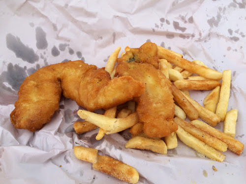
When we got back we had some great fish (blue cod & elephant fish) and chips.

Overall the trip to Stewart Island was worth it. It has a very different feel and a lot less tourists. The track was well maintained and not more than 150m of elevation gain at a time. Since they were easy hiking days we ended up at the huts in time for lunch and spent the rest of the days reading, exploring and relaxing.

Click here for more photos!


Friday, 20 March 2015

The Catlins

The Catlins is a region along the southern most end of the south island with rugged ocean coast lines intermixed with cattle and sheep farms. We spent a day driving along the Southern Scenic Route and stopped to see:

Slope Point.

which is the southern most point of the south island.

Waipapa Point Lighthouse where we saw some sea lions!

McLean Falls.

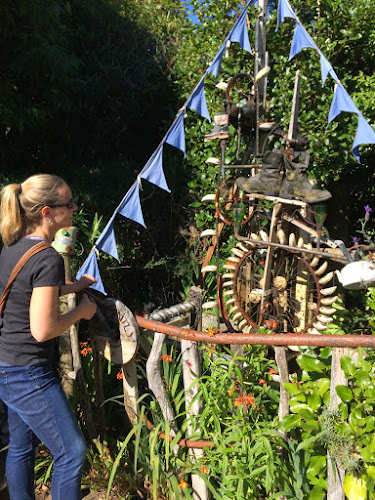
A very quirky, fun and interactive art gallery called The Lost Gypsy Gallery.

and finally Curio Bay to try and spot some yellow-eyed penguins and see the petrified forest. Unfortunately we were too early for the penguins and access to the petrified forest was cut off...The idea of a petrified forest though was really interesting and we were dissappointed we couldn't walk through it. Here's what the info panel said:

and here is what we saw:

The Catlins are a beautiful area of the country. It still amazes us to see so much farmland right at the edge of such rugged coastlines (those poor sheep!). While in the area we stayed at the Slope Point Backpackers, which is on a sheep and cattle farm. The kitchen was well equiped, everything was very clean, the bed was the most comfortable we've had yet and the owner Justine was extremely friendly! If you plan a trip in this area stay here!

Click here for more photos!


Thursday, 19 March 2015

Milford Sound

From Wanaka we next drove to Queenstown - the supposed adventure capital of New Zealand. The place was where bungy jumping was invented, but has since then expanded into every type of crazy activity you can imagine. Jet boats? Check. Giant swing with 100m freefall? Check. Zorbing? Check. Unfortunately, we had a terrible first night there at the Lakeside Hostel (do NOT ever stay there) and then a good second night at the Aspen Lodge Backpackers. Not really willing to shell out $200+ to get our adrenaline fix, we decided to instead opt for the free option and hiked up Ben Lomond Pk. which is right outside of town. It was a bit like the Grouse Grind in Vancouver at first with a 1400m climb from our hostel in town and then along a ridge with nice views of Mount Aspiring Park.

Other than that, this town is worth skipping unless you want to relive the early years of living in a University dorm room. Needless to say, we were pretty happy to be on our way.

We debated quite a bit whether or not to go visit Milford Sound next since we heard that the crowds were pretty terrible and the place has an endless stream of tour buses passing through during the day; however, we still really wanted to see the Darren mountain range in Fiordland next to Milford which we heard was pretty spectacular. As a compromise, we decided to brave the crowds and do the touristy boat cruise through the sound the first day, and then stay a bit off the tourist path in the Darrens for the night at the New Zealand Alpine Club's Homer Hut which is a hub for climbing in the area. The next day we would try and scramble up the Barrier Knob summit.

We opted for the last cruise of the day, and surprisingly Milford was relatively quiet with the cruise not even half full!

Just as we were getting on our boat, the majority of people were hopping back onto tour buses for their return journey home leaving the place really quiet (there isn't many places to stay IN Milford sound, with the closest town with accommodations more than 100km away).

The fiord is amazing with it's dramatic mountain relief and high waterfalls falling from the glaciers above straight down into the ocean. Fine - it was REALLY impressive. A bit touristy, but if you can see past all the iPad laden tourists snapping photos for their Facebook profile, there is something really special here.

To get into and out of Milford Sound, you have to drive through this impressive 1 km long one lane tunnel bored through solid granite that connects two steep glacier carved valleys (providing the only road access to Milford). Homer Tunnel has traffic lights on either side to control the flow of traffic as only one direction can fit at a time. The construction started in the 1930's as a make work project during the Depression and was completed in the early 50's. Funny thing is that the traffic lights only work until 8pm.... not sure what happens then. Must be pretty exciting.

The next day after sleeping at the NZAC's Homer Hut we hiked up to Gertrude Saddle. The hike is a steep climb up from the valley to the saddle and was well worth it. I was blown away by the sheer granite faces surrounding us on all sides.

Once we got to the top of the saddle, we got a taste for the famous Fiordland weather. Within the span of 10 minutes the weather changed from sunny skies to strong wind and snow! We decided to wait things out and see what would happen.

The views of Milford Sound were amazing from the saddle (at least what we could see before it started snowing)!

Once the snow stopped and the wind died down, we continued up the ridge to the top of Barrier Knob. The last bit of the climb was definitely a scramble with some exposed sections since we had to take a roundabout route to avoid the small pocket glacier near the summit.

The view from the the top was amazing!

The Darrens are beautifully dramatic and definitely worth the trip! I can't believe we considered skipping it.

Lessons learned: Skip Queenstown. Head over to Milford Sound, skip the cruise and hike up to the Gertrude Saddle and Barrier Knob (only if you're comfortable on loose crappy, crumbly rock)

After being in the mountains for a while, having an oven was pretty exciting. We earned some freshly baked scones and cinnamon buns!

Click here for more photos!!


Saturday, 14 March 2015

Mount Aspiring National Park and Wanaka

We loved the Alps so much that we wanted to do another hike to see more of the range before going on to Fiordland. Mount Aspiring is another famous peak in the NZ Alps and we wanted to find a hike that would get us high for some good views. Unfortunately the weather forecast was starting to turn on us...it changes so fast here that it can sometimes be frustrating to try to plan around. The forecast was for 1mm of rain over a period of 6 hours that would start the day we were planning on hiking back out. We figured we'd at least get one good day and a bit of drizzle on the way out so we went for it anyway. Unfortunately, we had a bit of a false start at first - we tried to drive our tiny rental car up the 30km+ gravel road to the carpark but we had to ford 9 rivers along the way. Fortunately, most of the rivers were low enough that we could blaze right through - until the second to last one. We were ALMOST there but this river was about at the bottom of our car doors and we thought that stalling and flooding our rental car in the middle of nowhere was not a good idea (not to mention voiding our rental insurance agreement). In the end we turned around and hired a 4x4 van to take us there the next morning.

Once there our plan was to find a camp spot in the valley, drop off our heavy stuff and then hike up to French ridge for a view with light day packs. The first two hours of the hike we travelled through private farmland (side note: most of the public park land is accessed through private farm land. It was explained to us that the farmers' land leases were up and in their re-negotiations with the government they were required to return some land back to the public for park use and must allow road access - pretty cool!). We walked through the most amazing farm land surrounded by towering mountains. These fields were all actively being farmed and were filled with hundreds of cows; turns out cows can be quite feisty!

Once in the park, we continued through this amazing valley for another couple of hours. Although it was cloudy, we still had some great views of glaciers and waterfalls.

We looked for a camp spot by the river but there were so many sandflies that we decided to keep going (sandflies are like black flies; they bite, they hurt and they are very annoying).

The final two hours up to French Ridge is hard. It's 1000m straight up a rocky and muddy track with conveniently placed tree roots as steps and handholds. It was so steep that we thought it should be classified as a whole new type of climbing - "Rootineering"? or "Treeineering"? Either way - it was pretty full on using all four limbs. Once we got to the top of the ridge we decided to camp instead of staying in the hut since we ended up hauling all our gear up just to avoid the sandlies. The clouds cleared a bit and we were able to get some amazing views of glaciers and the steep valleys in the area.

Our spot may have been sandfly free but definitely not Kea free! We were visited at our campsite by about twenty Kea's. At first they were super fun to interact with.

They are incredibly smart and curious (click HERE to see a video of one checking Tom out). However they got pretty annoying once we started making dinner. They would sneak up on you while you're not looking to either peck at something, try to steal your socks, or just play with the guy wires on the tent.

The weather started turning on us with a few showers over dinner and into the evening, as expected. Sometime in the middle of the night though, we were hit with some high winds and pretty hard rain! When we woke up in the morning the wind and rain were still going pretty hard and at this point we realized the forecast we read of 1mm of rain over a 6 hour period was wrong. It was going to be much much more than that! We packed up our tent around 5:30am, and headed into the hut for breakfast before hiking back down in the pouring rain through the steep muddy track that had turned into a waterfall.

Needless to say we were completely soaked...Luckily the rain stopped while we were hiking back through the valley and the sun came out just enough for us to dry off a bit.

The next day, we joined the locals in Wanaka at their farm fair. They had a lot of vendors (jewellery, clothing, food, furs, farming equipment), livestock competitions, horse jumping competitions, and a sheep dog herding competiton. Its great when we randomly stumble on these local events!

Click here for more photos!